Dublin

Geography of Dublin
Geography of Ireland
Ireland is an island located in North Western Europe and in the North Atlantic Ocean. It lies on the European continental shelf (the Eurasian Plate part) and it takes up most of the island with Northern Ireland (which it belongs to the United Kingdom).
In its 70,273 square km (27,132 square miles) of total area, its main geographical terrain are mostly low central plains surrounded by rugged hills and low, coastal mountains, as well as sea cliffs on west coast. It also has many coastal islands, including Achill, the country's largest, the Aran Islands to the southwest of Galway and Valentia Island just off the Iveragh Peninsula.
Regions of Ireland
Ireland is divided into 32 counties. In the Republic of Ireland official usage the term "county" is often conflated with these 32 areas currently used to demarcate areas of local government. The 32 divisions listed below include the "traditional counties of Ireland as well as those created or re-created after the 19th century:
- Louth
- Carlow
- Dublin
- Longford
- Monaghan
- Armagh
- Leitrim
- Fermanagh
- Kildare
- Laois
- Sligo
- Westmeath
- Waterford
- Cavan
- Offaly
- Wicklow
- Kilkenny
- Galway
- Mayo
- Donegal
- Kerry
- Clare
- Tyrone
- Antrim
- Limerick
- Roscommon
- Down
- Wexford
- Meath
- Londonderry
- Tipperary
- Cork
Cork, Dublin and, Galway are cities that are currently administered outside the county system, but with the same legal status as administrative counties.
Major Cities in Ireland
Dublin (city population 553,165 inhabitants) is the county chief commercial, industrial, administrative, educational and cultural centre, while Cork city (125,622 inhabitants) has traditionally been associated with the processing and marketing of agricultural products, the presence of large-scale industrial development around its outer harbour and the use of natural gas from the offshore Kinsale field. Waterford (48,369 inhabitants), Dundalk (32,288 inhabitants) and Drogheda (29,471 inhabitants) are smaller regional centres with industrial functions.
On the west coast, the main city is Limerick (58,319 inhabitants), which is located at the lowest crossing place on the river Shannon. It shares in the prosperity of the Shannon Industrial Estate but its harbour facilities are now little used, though significant port and industrial activities are developing westwards along the Shannon estuary. Other significant western urban centres are Galway (79,504 inhabitants) and Sligo (19,402 inhabitants).
Climate of Ireland
Ireland's climate is classified as western maritime and it is influenced by the Atlantic Ocean. The country receives generally warm summers and mild winters with abundant rainfall. Consequently the weather is considered mild, humid and variable with a lack of extreme temperatures, a characteristic that it shares with all the countries that lie in the path of the temperate depressions.
The temperature is almost uniform over the entire island and the prevailing wind usually comes from the southwest, breaking on the high mountains of the west coast.
- January and February are the coldest months of the year with daily air temperatures falling between 4 and 7 °C (39.2 and 44.6 °F)
- July and August are the warmest, reaching temperatures between 14 and 18 °C (57.2 to 64.4 °F) near the coast, and from 19 to 20 °C (66.2 to 68.0 °F) inland
- The sunniest months are May and June, with an average of five to seven hours' sunshine per day.
Rainfall is therefore a prominent part of western Ireland, with Valentia Island, on County Kerry west coast, getting almost twice the annual rainfall than Dublin on the east.
The precipitation, combined with the equable climate, it is remarkably favourable for the grasslands, which are the basis of the country's large livestock population.
For up-to-date weather information, consult "Met Éireann - The Irish Meteorological Service".
Time zone in Ireland
Ireland uses Irish Standard Time (IST, UTC+01:00) in the summer months, and Greenwich Mean Time (UTC+0) in the winter period.
Geography of Dublin
Dublin is the capital city of the Republic of Ireland and the largest city of the country, and its population is around 553,165 inhabitants.
The city is located near the midpoint of Ireland's east coast, at the mouth of the River Liffey and encompasses a land area of approximately 115 square kilometres (44 sq mi). It is geographically bordered by a low mountain range to the south and surrounded by flat farmland to the north and west.
A north-south division has traditionally existed in Dublin, with the dividing line being the River Liffey, which is further divided by two lesser rivers - the River Tolka running southeast into Dubin Bay, and the River Dodder running northeast to the mouth of the Liffey. Traditionally, the North side has been seen as working-class zone, while the Southside is seen as middle and upper middle class area.
Dublin is internationally noteworthy in terms of its vibrancy, nightlife and tourist attractions. Furthermore, it is also the most popular entry point for international visitors to Ireland and an economic, administrative and cultural centre with one of the fastest growing populations of any European capital city.
Districts in Dublin
Dublin is divided into 24 districts, separated by the Liffey River into Northern districts (odd numbers) — for example, Phibsboro is in Dublin 7 — and Southern districts (even numbers) — for example, Clonskeagh is in Dublin 14.
Between them, the most important are:
- North Area
- Dublin 1 encompasses most of the inner north of the city and includes O'Connell, Dorset and Henry Streets.
- Dublin 3 is home to Ireland's largest sports stadium Croke Park, headquarters of the Gaelic Athletic Association. Its main aim is to promote Irish national sports and regular tours of the stadium are conducted.
- Dublin 7 is home to the Four Courts complex, which contains the four main law courts of Ireland.
- South Area
- To the south of the River Liffey is Dublin 2, a frequent haunt for visitors. It includes the Temple Bar cultural quarter as well Grafton Street with its up-market shops. St Stephen's Green, Trinity College and the National Gallery are also located here.
- One of the best and most expensive residential areas is found in District 4. Here, mostly Victorian houses line Shrewsbury and Aylesbury Roads, many fine restaurants and fashion boutiques.
- Dublin 6 is the student's area. Cheap and lively neighbourhood with events running all year long.
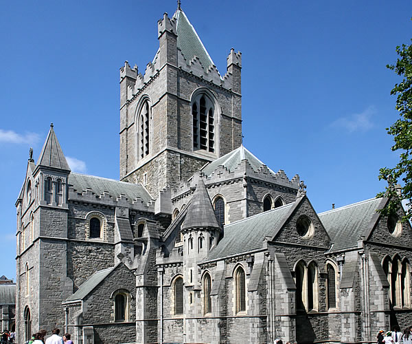
- Dublin 8 contains the historic Christ Church and St Patrick's Cathedrals as well as one of Dublin's great open areas, Phoenix Park. This spectacular park covers over 1760 acres.
- Rathfarnham Castle and Loreto Abbey can be found in district 14 on Dublin's Southside. Rathfarnham Castle can trace its beginnings to prehistoric times and Loreto Abbey is a beautiful mansion and home to the Institute of the Blessed Virgin Mary.
See that in some tourism and real-estate marketing context, Dublin is sometimes divided into 5 quarters:
- 'Medieval Quarter' (in the area of Dublin Castle, Christ Church and St Patrick's Cathedral and the old city walls)
- 'Georgian Quarter' (including the area around St Stephen's Green, Trinity College, and Merrion Square)
- 'Docklands Quarter' (around the Dublin Docklands and Silicon Docks)
- 'Cultural Quarter' (around Temple Bar)
- 'Creative Quarter' (between South William Street and George's Street).
Climate of Dublin
Dublin's sheltered location on the east coast makes it the driest place in Ireland, receiving only about half the rainfall of the west coast.
Similar to much of the rest of north Western Europe, a major warm ocean current called "the North Atlantic Drift" keeps sea temperatures mild too. So while the weather can be changeable - it's rarely extreme.
The city experiences long summer days and short winter days and strong Atlantic winds are only common in autumn. However, in winter, easterly winds render the city colder and more prone to snow showers.
The average maximum January temperature is 8.8 °C (48 °F), being the coldest month, while the average maximum July temperature is 20.2 °C (68 °F), the hottest month. Additionally, the sunniest months are May and June. Rainfall is evenly distributed throughout the year, and while the wettest month is October with 76 mm (3 in) of rain, the driest one is February with 46 mm (2 in).
Update 14/10/2017
Keep more of your money when transferring funds overseas!
If you want to move money abroad, from Ireland or to Ireland for example, Fexco provides efficient and secure global bank to bank transfers and bespoke payment solutions for both business and personal clients.
Why Fexco
Fexco provides a secure international money transfer service online or by telephone with bank beating fx rates and low fees. Specialises in high-value transfers.
Faster, cheaper, safer International money transfers.
Dedicated fx dealer who will oversee your transfer from start to finish
Make payments from anywhere with our secure online platform, PayDirect.
If you prefer the personal touch, then our payments team can be contacted by phone.
Main characteristics
Fexco will help you to keep your overseas money transfer costs to a minimum.
| Margin | 0.6% |
|---|---|
| Regulator | FCA |
| Fee | £10 < £5K or Free > £5k |
| Mini | £1K |
| Ccy | All (130 currencies, incl ‘exotics’) |
| Services | Repatriation of funds, Property, Regular payments, High Value payments, spot, online, telephone. |
Get an online quote today
When you are ready to make your transfer, John and his team will be available to help you with better rates and an unrivalled service to make sure your funds are delivered securely and speedily.
Do you have comments or personal information to communicate about this article? Add your comment.
Find links about overview / geography of Dublin and a lot more in The links of expatriation.
Find more definitions and general answers on expatriation issues in the Expat FAQ (Frequently Asked Questions).
Go to the Forum to talk more about geography of Dublin, overview.